FOB Price
Get Latest Price|
1 Piece Minimum Order
Country:
China
Model No:
T100/T200
FOB Price:
Place of Origin:
-
Price for Minimum Order:
-
Minimum Order Quantity:
1 Piece
Packaging Detail:
-
Delivery Time:
-
Supplying Ability:
-
Payment Type:
-
Product Group :
Contact Person Chailyn
Wuhan, Hubei
Product Description
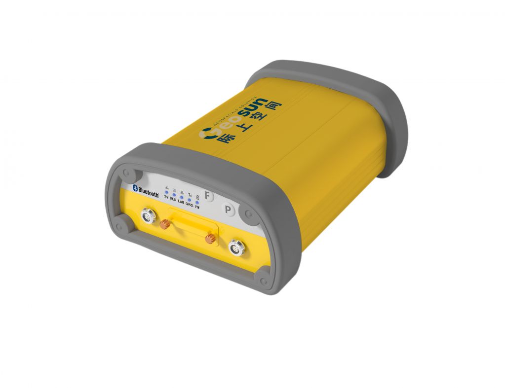
Rock series products are professional measurement type GNSS
receivers which are specially designed for CORS reference
stations, deformation monitoring system and etc. It adopts the
latest high-precise GNSS OEM mainboard which is compatible with
single and double frequency modules. Real-time data
transmission is available through RS**2 interface, cable
network and GPRS wireless communication network. The data
sampling rate is up to *0Hz.
It supports various kinds of GNSS signal, including the GPS,
GLONASS, Galileo, and SBAS signal such as WAAS etc. With many
parallel receiving channels, Rock series receivers can greatly
improve the tracking and observation of the GNSS satellite
signal, so does the functions of high-precise surveying and
real-time RTK surveying.
| Functions & Features | |
| Based on Linux | Based on core Linux, it is a real multi-user, multi-task, multi-platform operating system. The system has strong stability, powerful management and network functions. Embedded with microprocessor design, it is small, consumes less power, produces less heat, which meets the long-time continuous working requirement. |
| Support main stream GNSS signal | There are many parallel receiving channels, which can maximally track and observe available GNSS satellite signals. Such as the GPS, GLONASS, and Galileo signals. It can get nearly 2 times satellite signals than using GPS alone, thus improves the surveying accuracy and RTK performance. |
| *0Hz data update rate | Data update rate is up to *0Hz, while maintaining the best quality of observation and independence of the observed value. Only 4W power consumption. |
| Multi-task | Perform multiple tasks at the same time. It can continuously track and record the satellite data, and provides data files which can be downloaded by the operators at the same time, and can calculate and send different RTK or RTD data simultaneously without any data interrupt and missing. |
| Multiple data transmission modes | Wireless radio, Ethernet (via RJ*5 interface to *0M/**0M network), built-in GPRS wireless communication function, and Bluetooth. |
| Massive data storage, download, transmission | Built-in 1G Byte high performance storage, support 2G Byte large-capacity industry grade SD card, and can support up to *2G Byte Micro SD card. 1G Byte storage can store 5 seconds sampling rate, 3 months double frequency GPS raw data; with 2G Byte SD card, 9 months double frequency GPS raw data can be saved. The data is stored as files, which can be downloaded on the computer or remote website, and can be cycle stored. |
| High-precise surveying technology | It adopts GNSS core algorithm with excellent performance, thus the surveying data has the highest level quality insurance. With long as several hundred kilometers baseline, the accuracy can reach: horizontal: ± (2.5 mm*1x*0 *6 D), vertical: ± (5.0 mm*1x*0 *6 D). |
| Excellent compatibility | It has excellent compatibility. The GPS raw data can realize the seamless compatibility with the CORS system through RTCM3.0, RINEX, and BINEX formats. It can be used to build new CORS system or expand the existing CORS system. |
| Remote network access | Built-in WEB server. Ordinary browser can be used to access Rock. |
| Data interface | One independent build-in RS**2 communication port COM1 for RTK or RTD data broadcast. Via this port, weather instrument and clinometer etc. can be connected to Rock, and the weather data and the leaning data can be recorded with the GNSS data together and be downloaded to the data center automatically. This provides more flexible for creating a perfect multifunction GNSS reference station. |
| Data storage & recode |
Memory
1GB MicroSDcard 2 GB Default update rate 1Hz Max updating rate *0 Hz Storage format RINEX, BINEX File name Diversified Data index and transfer Download from network |
| Input/Output format |
Differential message: CMR, RTCM2.3, RTCM3.0, RTCM3.1 Observation data: RINEX, BINEX Positioning data/status information: NMEA****3 V2.3 |
| Operation /output | Data of weather instrument (optional) or clinometer (optional) into communication serial port COM1 by sensor, so do radio station (optional) data transmit-receive. |
| Industry grade design | Industry grade design, rugged and sealed aluminum alloy case, water and dust proof; both ends of instrument are special rubber ring design, high shock-proof performance. |
| Choke antenna | Can connect professional choke antenna and rejection panel antenna, can effectively reduce multipath signals influence, accurately track main-steam GNSS signals. |
| User interface | Web User Interface |
| Power mode |
Built-in two independent power ports, receive 7V~*8V
voltage , *2V standard voltage, 4W power, with
KQ UPS (Uninterrupted Power System). Support alternating current (AC), storage battery, solar power and wind energy power supply. Automatic reset function helps to restore the device to the latest status after power down. |
| Country: | China |
| Model No: | T100/T200 |
| FOB Price: | Get Latest Price |
| Place of Origin: | - |
| Price for Minimum Order: | - |
| Minimum Order Quantity: | 1 Piece |
| Packaging Detail: | - |
| Delivery Time: | - |
| Supplying Ability: | - |
| Payment Type: | - |
| Product Group : | GNSS Instrument |


 --Centimeter Accuracy")
 --Centimeter Accuracy")
 --Decimeter Accuracy")
 --Meter Accuracy")


")


