FOB Price
Get Latest Price0 ~ 10 USD ( Negotiable )
|1 Minimum Order
Country:
China
Model No:
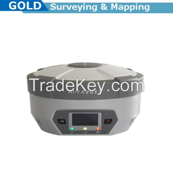
H32
FOB Price:
0 ~ 10 USD ( Negotiable ) Get Latest Price
Place of Origin:
-
Price for Minimum Order:
-
Minimum Order Quantity:
1
Packaging Detail:
Carton box
Delivery Time:
7-10 working days after receiving the payment
Supplying Ability:
100 Set per Month
Payment Type:
L/C, T/T
Product Group :
Contact Person Gold
9F/10 Jintai building, Nanping dist, Chongqing, Chongqing
Main
Features:
Multi Constellation Tracking
*2 channels, the H*2 is fully compatible with GNSS constellations to track GLONASS, GALILEO, SBAS as well as GPS.
All-in-one Transceiver UHF Radio
The transceiver UHF radio enables the H*2s working mode to be switchable between base and rover in the same receiver. The H*2 provides excellent performance in UHF RTK operation with its built-in transceiver UHF radio, which has adjustable transmitting power from 0.1 watt to 2 watt.
Seamlessly Operation in CORS System
With internal GPRS modem, the H*2 works perfectly with corrections from CORS networks in any version of CMR, RTCM without needing to interpret the message but reading seamlessly.
Powerful Battery
Powered by ***0mAh Li-Ion battery.
Static working time ****5 hours
RTK Rover (UHF/GPRS) working time ****2 hours
RTK Base working time ***0 hours
Rugged design, IP*7
The special latching technology on flexible flat cables ensures trouble-free operation under impact or vibration. The H*2 withstands 2 meters natural fall onto concrete.
Field Controller and Software
There are optional field controllers and software in the H*2 package. The controller with OS Microsoft Windows Mobile 6.5 are fully compatible with the third party software such as Carlson SurvCE, MicroSurvey FieldGenius, Digiterra Explorer, Esi ArcPad etc. Besides standard field&GIS software made by Hi-target. Hi-target controllrt with WIFI, Bluetooth, and GPRS/3G is completely wireless to connect to any device, collect data and connect to server simultaneously and seamlessly.
Post-processing Software
Hi-target Geomatics Office (HGO) software provides total GNSS solution with a complete suite of programs to support Hi-target GNSS receivers. Standard Rinex data and Hi-target raw data can be processed flexibly and easily.
Original from Hi-targets sophisticated GNSS technology, H*2 is a very competitive GNSS RTK system on the current market with its rugged design and affordable price.
The H*2s housing is made of General Electric Xenoy ***0U polymer resin to handle severe and harsh filed conditions. With its unique internal design, it can perfectly avoid or lessen obstruction and multipath effect to ensure superior positioning capacity.
The H*2s front control panel with super bright OLED display screen (resolution **8**4) makes the work more intuitive. No matter it is in the dark or strong sunlight, the screen is comfortable readable to your eyes.
Measurements
*2 channels
Proven NovAtel GNSS technology
Multipath mitigating technology
Auxiliary strobe signals, including a configuration output for time synchronization and mark s.
Satellite signals tracked simultaneously
GPS: L1,L2,L2C
GLONASS: L1;L2
Positioning Performance
Static and Fast Static GNSS surveying
Horizontal: 2.5mm + 0.5ppm RMS
Vertical: 5mm + 0.5ppm RMS
Post processing kinematic (PPK/Stop & Go) GNSS surveying
Horizontal: 1cm + 1ppm RMS
Vertical: 2.5cm + 1ppm RMS
Initialization time: typical *0 minutes for base while 5 minutes for rover
Initialization reliability: typically > *9.9%
Real-time Kinematic (RTK) surveying
Horizontal: *0mm + 1ppm RMS
Vertical: *0mm + 1ppm RMS
Initialization time: typical *9.9%
Code Differential GNSS positioning
Horizontal: *5cm + 1ppm RMS
Vertical: *0cm + 1ppm RMS
SBAS: 0.6m horizontal
Hardware
Physical
Dimensions (M * H): *6.5cm * *0.5cm (6.5 in * 4.*3 in)
Weight: 1.*5kg (3.*6ib) with internal battery, internal radio, standard UHF antenna
Operating temperature: **5C to **5C (**9F to ***9F)
Storage temperature: **5C to **5C (**7F to ***5F)
Humidity: **0%, considering
Water/dust-proof: IP*7 dust-proof, protection from temporary immersion to depth of 1m (3.*8ft)
Shock and vibration: designed to survive a 2m (6.*6ft) natural fall onto concrete.
Display: **8**4 resolution, 1.*4 inch OLED screen.
Electrical
Power 6V to *8V DC external power
Power consumption 2.5W
Automatic switching between internal power and external power rechargeable, removable 7.4V, ***0mAh lithium-ion battery in internal battery compartment.
Internal battery life:
Static ****5 hours
RTK Rover (UHF/GPRS) ****2 hours
RTK Base ***0 hours
I/O interface
1 * Bluetooth
1 * standard USB2.0 port
2 * RS**2 serial port
2 * DC power (*-pin & *-pin)
| Country: | China |
| Model No: | H32 |
| FOB Price: | 0 ~ 10 ( Negotiable ) Get Latest Price |
| Place of Origin: | - |
| Price for Minimum Order: | - |
| Minimum Order Quantity: | 1 |
| Packaging Detail: | Carton box |
| Delivery Time: | 7-10 working days after receiving the payment |
| Supplying Ability: | 100 Set per Month |
| Payment Type: | L/C, T/T |
| Product Group : | gps rtk system |


 Absolute Encoding Dual-axis Compensation Land Surveying Total Station")


