FOB Price
Get Latest Price( Negotiable )
|1 Set Minimum Order
Country:
China
Model No:
Drone Accessories
FOB Price:
( Negotiable ) Get Latest Price
Place of Origin:
China
Price for Minimum Order:
-
Minimum Order Quantity:
1 Set
Packaging Detail:
box
Delivery Time:
15-20days
Supplying Ability:
2000 Set per Month
Payment Type:
T/T
Product Group :

Contact Person Ms. Anni
room607, Building A, Xinghe Century Building, Futian District,, Shanghai, Other
Product Description
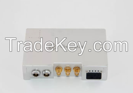
GPS BDS GLONASS GNSS INS System For Positioning And Altitude
AGS **0 GNSS INS System adds a high-precision inertial navigation (IMU) module, no matter how the fuselage tilts during the aviation flight, it can accurately provide position, velocity and 3D attitude information.
After the data processing of professional software, AGS **0 provides threedimensional position accuracy of 0.*5 m, velocity of 0.*2 m/s, heading of 0.**0 degree, and pitch/roll of 0.**0 degree, data sampling rate ups to **0Hz. With AGS **0, UAV Aerial remote sensing can completely be free from ground control point, it is especially applied to the UAV surveying in strip area, irregular shape area, large watershed area and high latitude area; and is also widely used in UAV laser scanning and other direct geo-reference aerial remote sensing fields. For the users who required high-precision and real-time in precision agriculture, electricity and other areas, AGS **0 also offers GNSS real-time differential positioning (RTK) function.
Specification
| Tracking Signal | GPS: L1 C/A code, L2 C, L1 / L2 ; |
| BDS : B1, B2a, B3 | |
| GLONASS: L1 C/A and P code, L1 /L2 , L2 P code | |
| Processor | Processor : **0 MHz ARM 9 industrial processor |
| Build-in Ram | Build-in RAM : 2 x *4 MB SDRAM |
| Build-in Flash | Build-in flash : 4 MB data flash; 1 GB nand flash |
| SD Card Storage | Standard 8 G micro SD card, max support up to *2 GB |
| Updated rate | Default update rate 5 Hz, max update rate *0 Hz |
| Storage format | Rinex, Binex |
| Indicator | 4 LED indicators, same function, indicate GNSS signal and power, 3G connection indicator |
| and antenna working indicator | |
| PW/EVEN/PPS/RS**2 | One lemon 9 pin interface, one lemon 6 pin double interface |
| Antenna interface | One external antenna interface, one UHF antenna interface, one 3G antenna interface |
| Mini usb interface | One mini USB port |
| Micro SD card slot | One micro SD card slot |
| Micro SIM card slot | SIM card slot |
| Dimension (mm) | **5**5**4 |
| Weight (g) | **0 , **0 with Cover |
| Voltage (v) | ***6 |
| Power consumption (w) | 3.3 |
| Working temperature | - *0 ℃*- *0 ℃ |
| Storage temperature | - *0℃*- *0 ℃ |
| Pitch & Rolling | 0.**5 deg |
| Heading | 0.*8 deg |
| Speed | 0.*2 m/s |
| Positioning Accuracy | **5 cm |
| Country: | China |
| Model No: | Drone Accessories |
| FOB Price: | ( Negotiable ) Get Latest Price |
| Place of Origin: | China |
| Price for Minimum Order: | - |
| Minimum Order Quantity: | 1 Set |
| Packaging Detail: | box |
| Delivery Time: | 15-20days |
| Supplying Ability: | 2000 Set per Month |
| Payment Type: | T/T |
| Product Group : | Drone |